

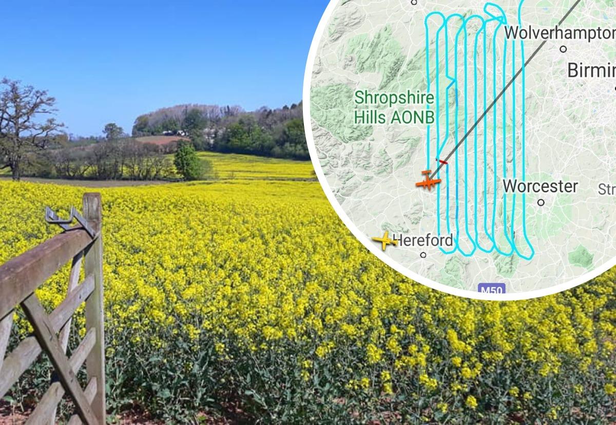
PLANES have been spotted zig-zagging in the skies above Herefordshire and people have been left bemused by the reasons for the unusual flightpaths.
On Wendesday (April 22), one plane was seen flying back and forth above the county, with Flightradar24 showing the flight map for the plane – a Beech 200T Super King Air.

The reason for the zig-zagging flight path is thought to be down to aerial surveys being carried out.
RELATED NEWS: Striking picture captures unusual aircraft in flight
Bluesky International Ltd operates multiple aerial survey cameras and Light Detecting And Ranging (LiDAR) systems.
A spokesperson for the company said: "Bluesky maintains a three year update programme of vertical aerial photography in England, Wales, Scotland and Ireland which is then processed and corrected so it is map accurate.
"The resultant data is licensed to both the public and private sector for applications such as planning, flood modelling, coastal erosion analysis, map production, civil engineering projects, forestry management and disaster planning.
"In addition, Bluesky captures LiDAR data which is highly accurate height data of vegetation and manmade features providing invaluable three-dimensional information for planners, architects, engineers and telecommunications."
While the skies above Herefordshire may not be the busiest in the country, at the beginning of March air traffic in the UK was down by almost 90% compared with this time last year, the National Air Traffic Service (Nats) revealed.
Only 832 flights were handled in UK airspace on Thursday 2 April, compared to 7,240, which were handled on the equivalent flying day last year – a decrease of 89%.
“Traffic has consistently been down by 89% since Tuesday,” a spokesperson for Nats said.
Military flights, air ambulance, police and goods delivered via air freight are still operational, but commercial air travel has been vastly reduced worldwide.


Comments: Our rules
We want our comments to be a lively and valuable part of our community - a place where readers can debate and engage with the most important local issues. The ability to comment on our stories is a privilege, not a right, however, and that privilege may be withdrawn if it is abused or misused.
Please report any comments that break our rules.
Read the rules hereLast Updated:
Report this comment Cancel