
THE River Leadon is a bit of a secret, really. It is, at least, in the Herefordshire third of its 30-mile journey. Rising above Evesbatch on Fromes Hill, it sneaks stealthily southwards through unobtrusive Bosbury towards the western fringe of Ledbury.
Our walk takes us into a particularly scenic stretch of the enigmatic river’s delightful valley. From orchards, the route upstream is a level one between two bridges which, though as anonymous as the river itself, act as convenient landmarks. The return involves a couple of modest climbs through pasture but opens up a fine vantage of the valley’s wooded slopes.
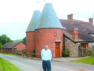
At Notehouse Farm there is a reminder that we are in one of the great hop-growing areas of the county. The building used for drying hops in order to preserve them is known as an oast house in Kent and the south-east, but as a hop kiln in Herefordshire.
Especially familiar in the Frome as well as the Leadon valleys, the kiln is traditionally built square from local red brick and tapers into a conical roof of Welsh slate. The operational principle involves dry, warm air being drawn up from a heat source on the ground floor through a bed of hop cones spread evenly across the floor above.
The draught is created by a venting cowl, resembling a witch’s hat, which turns freely on a small circular runner with a tail enabling it to follow the wind direction.
Before the advent of kilns fired by oil burners, the drying process was a round-theclock manual business.
It was in the hands of highly skilled and trusted operators who stoked the fires and regulated the humidity and temperature.
The driers would have their own resting quarters on site for the duration of the harvest.
There were some resourceful ploys invented to stop them falling asleep at a critical time, and one imaginative individual would cause himself to be bashed on the head by a bottle if he dropped off.
A more regular approach, however, was to sit in a wheelbarrow with the handles resting on the ground; if the occupant nodded off, the barrow would tip and wake him up.
In the 1920 heyday of the manual picker, 10 to 12,000 would report for their September duty in the Herefordshire hopyards. For many of them travelling from the Black Country and South Wales the expedition was treated as a family holiday.
They were housed in purpose- built hutment barracks, wooden or corrugated iron structures, bell tents, or army Nissen huts. The less pampered, however, would find themselves sleeping in barns, stables, haylofts, pigsties and cowsheds.
By the time that scion of Ledbury John Masefield got around to writing chapters of his autobiography in 1952, picking machines were beginning to replace mortals in the hopyards.
He had spent his childhood “looking out on these red ploughlands and woodland and pasture and lovely brooks”.
“I know no land more full of bounty and beauty, so good for corn and hops and roses.”
Following his formative years as a sea cadet, bar and mill worker in New York, bank clerk in London (counting 323 chimney pots from his grimy lodgings), and journalism in Manchester, he had embarked on 37 years as Poet Laureate in 1930.
“Whenever I think of the bounty and beauty of God”, he announced in Hereford Town Hall, “I think of parts of this county”.
Thus re-assured that nostalgia isn’t quite what it used to be, the walk won’t see us finish too leaden-footed. And the river will still be a bit of a secret, really.
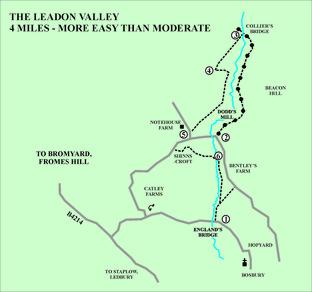
The Upper Leadon Valley.
Secluded river valley, grassy old Roman road, lanes.
Four miles. Easy out, moderate back, with one gradual climb.
Map: Explorer 202, Leominster and Bromyard.
Public Transport: Sporadic buses to Bosbury.
The route. Start at GR 693440
1. England’s Bridge. Grass verge space for five cars 100 metres east of unremarkable bridge by bend in lane half-a-mile NNW of Bosbury church, or half-a-mile beyond public telephone if approaching from B4214, signed Catley, sharp turn from north. So walk 100m NW to cross high stile, right, before bridge parapet to follow left direction along left (river) edge in orchard. At hedge in front cross stream via stiled footbridge and bear right in field up gentle slope along right edge/hedge to cross stile by double gate into lane, left of black and white cottage. TL for half-amile along lane past Bentley’s Farm to left bend.
2. Poplar bend. In front of tall trees fork right up unsigned drive, with grass in middle, to go right of approach to Dodd’s Mill above thatched Millcroft Cottage through unmarked metal gate. Follow broad path with views opening out, down through right of double metal gates below Beacon Hill wood, up ahead to skirt R of trees, ahead at marker post, through shady bit, ahead through waymarked gate, bend left to pick up wire fence through last gate on this Roman avenue. Turn left, as soon as you can, back down to bridge over shadowy river.
3. Collier’s Bridge. Cross through gate and head up bank through the (usually open) left option gate. Now contour up the sloping pasture and maintain a line beyond oak tree and smaller tree with light trunk to find a stile in the hedge about 40 metres below the far top corner. You need to track up ahead very slightly right from the field entrance.
4. Top stile. Cross stile in hedge for the walk’s highest perspective of the Leadon Valley. Wave to May Hill. TL down left edge/hedge to find a stile in bottom corner. TR and maintain line below gate, left of a short line of trees to cross stream below via bridge through gap. Rise up beyond (and ignoring) waymarker on right to a gap through (usually open) gate. With Millcroft Cottage over to left, stay on top right of bank towards Marcle tower, if visible, then drop to gated gap in hedge,and back up to lane in front of Notehouse Farm, with hop kiln.
5. Notehouse Farm. TL down lane to junction, then TR for 300 paces. TL through gate by grid for Shinnscroft along wide gravel drive. Follow it left then right through a gateway and just before the cattle grid in front of Shinnscroft TL down drive to left of hedge, and TR over stile before and above cottage. TL down left edge then angle right 40m to cross river via high stile on footbridge.
6. Path junction. TR along river edge to cross rickety offset stile into the orchard beneath Bentley’s Farm. Go through gap in fence, then gate hidden in right corner of clumpy field and along bottom R edge of walk’s original field and back over stiled f/bridge. Follow R edge of orchard and TL back over stile on to lane and starting point


Comments: Our rules
We want our comments to be a lively and valuable part of our community - a place where readers can debate and engage with the most important local issues. The ability to comment on our stories is a privilege, not a right, however, and that privilege may be withdrawn if it is abused or misused.
Please report any comments that break our rules.
Read the rules here