
BREATHTAKING borderland views are in store on our Christmas walk from Knighton, “Tref-y-Clawdd” the Town on the Dyke. We set out from the Offa’s Dyke Centre in West Street, where welcoming staff, a treasure trove of Ordnance Survey maps, walking guides, home-made cakes, gifts, and a coffee shop are to be found. After ambling down past the Gothic clock tower - a place you could sell the wife in more enlightened times (?) - cross the river by the railway station and take the stiff climb up through the wood towards the Offa’s Dyke Path; this will definitely banish those winter cobwebs.
Offa was King of Mercia from 757 to 796, and overlord of the whole of England south of the Humber. His dominion extended over Kent, Sussex, Wessex and East Anglia, and he wielded as much power as any of the Anglo-Saxons apart from Alfred the Great. Over the course of forty years, he employed more than a thousand labourers to dig out a great earthwork by hand; the huge ditch they constructed was backed by a rampart 30 yards wide and 25 feet high. It ranged for a distance of about 150 miles along the border, and its purpose was to keep a careful watch over the Welsh in the west and gain advance warning of any raids. Although the Offa’s Dyke Path follows the Dyke for more than 50 miles, it actually criss-crosses the border for 177 miles; Knighton is half way along its course between Prestatyn and the Severn Estuary near Chepstow.
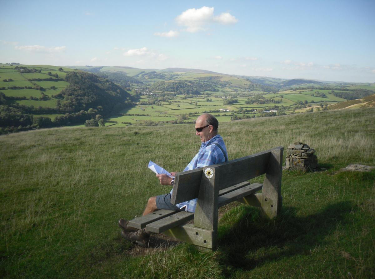
A couple of benches give us a chance to catch our breath before carrying on to the Dyke itself, where the seat (pictured) dedicated to a local man celebrates his love of the view across the Teme Valley to Knucklas.
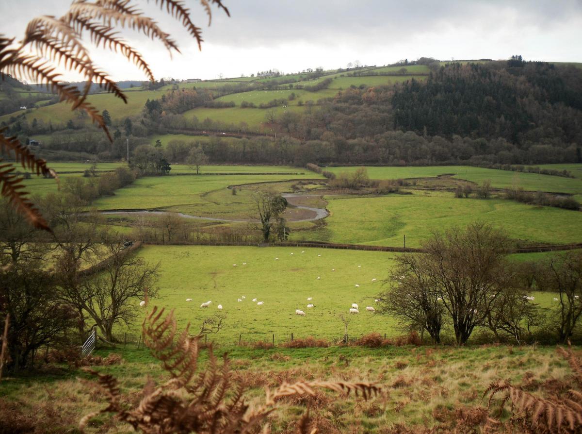
Legend associates Knucklas Castle with the marriage of King Arthur and Guinivere. A more likely episode in its history saw it being destroyed by the forces of Owain Glyndwr in 1402; it is the neighbouring Knucklas Viaduct, however, which catches the eye. Completed in August 1863, the structure stands 69 feet tall and has 13 arches with a span of 35 feet 9 inches; it has a crenellated parapet with round towers at each end and square towers at the buttresses. Near one of the parapets, built partly with stone from the old castle, an inscription recalls the tribulations of a fox being chased by the local hunt in 1925. Scrambling across the viaduct from the Castle Hill end, and trapped by workmen walking towards it from the Knucklas Station end, it leapt into the Heyhope Valley below.
The ‘thirteen arches’ were mentioned by British traitor William Joyce (‘Lord Haw Haw’) in one of his infamous Sunday evening radio broadcasts during World War II, and the viaduct was put under very close guard at the time. The railway line survived not only the war but also Doctor Beeching’s cuts in the 1960s when Reverend Proctor conducted a public service next to the track to commemorate the fox’s travails.
Offa’s Dyke Heritage Centre is open 10 till 4 every day apart from Tuesdays for the time being. Why not go along and enjoy one of the exhilarating walks. It’s our Two for One Christmas Offa.
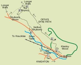
Knighton and Offa’s Dyke
Heritage Centre, town, woodland, spectacular moorland, riverside.
4¾ mile moderate/energetic ramble, mostly good terrain. Stiff climb.
More country lane in the 7¾ mile energetic walk.
Map: OS Explorer 201, Knighton and Presteigne.
The Route
1. From Offa’s Dyke Centre, Knighton, TL past clock tower. TL down Station Road as if for Bishop’s Castle, cross railway and TL along Kinsley Road.
2. At Gillow, TR up path into Kinsley Wood, forking L after just a few paces. Now climb almost vertically (!) until you emerge from trees by two benches at a plateau and a forest track. Keep ahead, across track, back into wood, but less steeply than before. Bear R to a ridge and low marker post. TL and climb a little higher through conifers. Descend under Scots Pines and your grassy path joins a track which bears very slightly R. Drop a little further and sweep around to R.
Before a parking Area, T very sharp L on yourself, through farm gate, into meadow (with barn in it, over to R). Follow bridle track along L edge, over brow to far end of meadow. Edge over to R to take less obvious path under oak trees and cross, possibly hidden, stile.
3. Offa’s Dyke Path Finger Post. TR, immediately keeping ahead, (and not L). You now follow the well-marked Trail for a spectacular 1¼ miles to
4. Cross paths, which are 300m before a conifer plantation.
(The longer, more energetic walk continues ahead going a little L around the head of the combe, up past the trig. point on Cwm-sanaham Hill and ahead, descending quite steeply beyond a white cottage, Brynorgan, to the road.TL for Selley Cross, and at crossroads, TL for Skyborry, 1½ miles. 20m before junction at Skyborry Green - “Knighton 2”, T sharp L between barn and industrial unit, up wide, aggregate bridle path, steeply beyond tower, through gate at The Brynny. TR to Point 5).
Shorter walk. TL down the 12m wide aggregate track as if for Knucklas Viaduct, for about 350m to marker post. TL a few paces to 2nd post, behind cream house, The Brynny.
5. Marker post behind The Brynny. Having turned L, go ahead along a narrow, grassy path between trees, with fence R, dropping down through bracken. Keep to lower edge, fence R. Go over 2 planks, through gate, ahead, then go R through k-gate, across stream to rejoin fence on R, and dropping. Pass marker, swinging L, and go L of post along bank to pass waymarked fence elbow. Keep ahead, cross trickle, stile above cottage, stile, gate, and go L along track, with cottage behind you. Reach surfaced lane and go R.
6. Nether Skyborry. TL for ½ mile (800m), along the road. About 60m before Panpwnton farm, TR on to Offa’s Dyke Path. Cross the railway and River Teme. Follow the right bank past some benches and the bridge which marks the border. Take next R to the Offa's Dyke Centre.


Comments: Our rules
We want our comments to be a lively and valuable part of our community - a place where readers can debate and engage with the most important local issues. The ability to comment on our stories is a privilege, not a right, however, and that privilege may be withdrawn if it is abused or misused.
Please report any comments that break our rules.
Read the rules here