
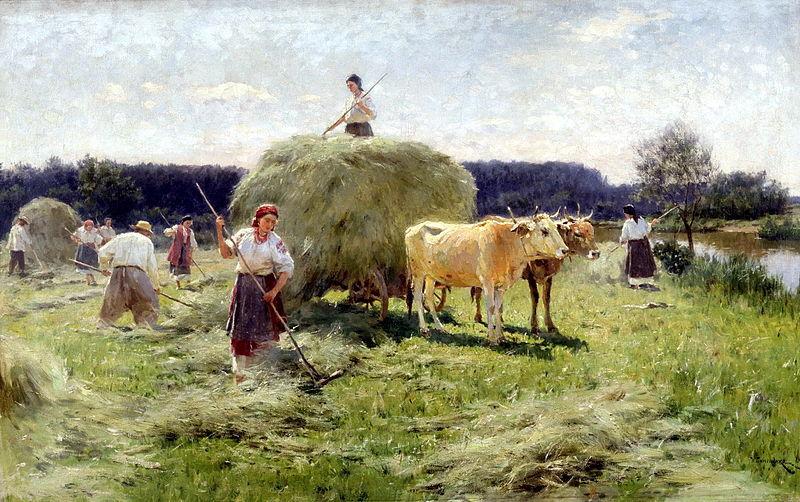
BODENHAM Making Hay
BODENHAM Lake Nature Reserve occupies 110 acres of varied habitat, with riverside meadows, veteran and newly-planted orchards and wet woodland. If you decide to take a stroll around after doing our family walk this month, you may well see mallard, wigeon and teal dabbling; goldeneye and tufted duck diving; goosander and smew feeding on fish, and cormorants perching in trees on the various islands.
Soon after leaving the park at Bodenham Lake Nature Reserve there are plenty of reminders of an earlier heyday. The lake occupies the site of old gravel pits which filled with water as they were dug out in the 1980s; the old pits themselves were formerly meadowland. Though the Romans were equipped with scythes, it’s not really known when the huge floodplain grasslands of the Lower Lugg valley became hay meadows instead of pasture; but by the time of the Saxons, haymaking was commonplace, and by Norman times nearly all settlements had their own meadows. By then, they were rated of greater value than arable and were all carefully recorded in the Domesday Book in 1086. The way the land was used meant inhabitants held strips, or “doles”, in the common hay meadow where they were entitled to cut hay for their own use. When the hay had been cut and carried and the grass had had a chance to grow again, the animals of the settlement were allowed into the meadow to graze the aftermath. This usually took place on Lammas Day (August 1st). The animals remained in the meadow until winter or sometimes on until Candlemas (February 2nd) when the meadow was “shut up” again for the hay to grow.
The open field system of agriculture became more widespread over the country from the 11th to 14th centuries, but common meadows continued to be an important feature. This was where the hay was grown to feed the plough oxen and other stock through the winter. Not all the meadows, however, were held in common. The Lord of the Manor, as well as holding strips in the common meadows often had a “demesne” meadow of his own. In the old township of Bodenham Devereux, Court Meadow was one of these. The landowners from the 12th century until 1803 were the Devereux family, and the house where they held court from the 15th century lies on the eastern edge of their demesne. The black and white, timber-framed house is on the left of our path, between the start of our walk and the church, but now rather obscured from the public gaze.
The system gradually started to change, and the meadows were enclosed piecemeal from about 1700 onwards. Manorial courts began to lose their power and in most places the change from communal to private ownership of land was complete by the Enclosure Act of 1813.
Lugg Meadows, in vibrant wildflower just outside Hereford, still survives more or less in its original form. It’s the best example of a medieval common meadow now left in the whole of Britain.
Around Bodenham (Boda’s land in the river-bend), Mitley, Smeadal and Great Meadow were the ancient common meadows on the floodplain. Mitley is now pasture between the church and Ashgrove Wood, while Smeadal and Great Meadows have become mostly arable fields either side of Smeadal Lane which we take to follow the Lugg back to Church Bridge. This is an ancient crossing place where shallow water reveals an old stone ford below, and it’s still a point where networks of footpaths converge.
The old meadows, the timeless part of the village around the church, and the northern part of the parish of Marden make for a pleasant family walk with surprising views.
Bodenham and Marden parish.
Pasture, riverbank and country lane. Good views.
3½ mile easy walk, but with two short, sharp climbs. 13 stiles, 1 footbridge.
Map: OS Explorer 202, Leominster & Bromyard.
Public Transport: Bus 426 calls at Memorial near start of walk.
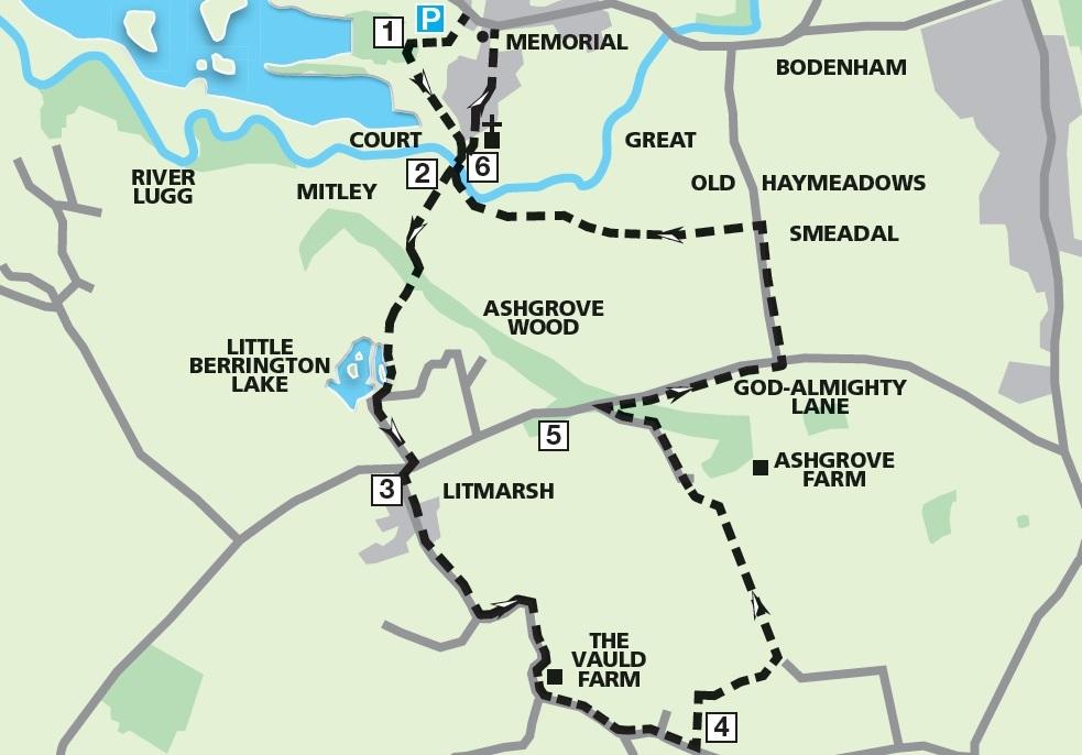
The Route
1. Bodenham Lake Nature Reserve. From car park go (west) through the gate as if towards the canopied Information Board. Instead, TL back (L) signed for the church. Follow wide path through 2 gates, passing Devereux Court. TL through bridle gate to path junction and TR across Lugg via Bodenham church bridge.
2. Mitley Meadow. Go straight ahead across old meadowland, now pasture, for Litmarsh. Cross f/bridge into Ashgrove Wood. Go L steeply up handrailed steps. Bend L and R as path levels, out through gap for fine views. Follow L edge down to pass Little Berrington Lakes. TL to reach and cross stile. TR, and L after 35m. Follow gravelled drive to surfaced road. TR and after 20 paces, TL for Litmarsh.
3. Litmarsh. Pass The Arles, Litmarsh Farm and bend L at Monmarsh End. TR at Red Barn Farm. Bend R at Cider Mill Barn. Pass the black and white The Vauld Farm and follow the main surfaced lane left. At Vine Villa bend L to the far end of Norton Court.
4. Norton Court. TL up bank across 2 stiles into pasture, up L edge to a gate. TR in front of gate to put fence on L. Cross stile, up channel, next stile, up R edge of crop field. Just before top edge, go L over step stile in hedge. TL along the wide footpath (with very fine views). Cross stile/gate, along L edge, through walkers’ gate, along farm drive and TL over 3 plank bridge. Cross stile on permissive path around fence (R), through gate, over stile and TL down Ashgrove Farm drive. (Cider mill). Go through gate by grid to road.
5. “God-almighty” Lane. Turn sharp right steeply down for ? mile to road junction. TL along Smeadal Lane to footpath sign on L. TL over awkward stile into field. Go ahead and cross stile, aiming for church, just R of tree in field, stile by Lugg elbow, downstream, next stile and re-cross bridge to church.
6. Go into churchyard, along path, through lych-gate, by cobbled pavement, ahead along Church Walk. Go left opposite school, TL at the War Memorial, 70m past Coach House to Car Park drive.


Comments: Our rules
We want our comments to be a lively and valuable part of our community - a place where readers can debate and engage with the most important local issues. The ability to comment on our stories is a privilege, not a right, however, and that privilege may be withdrawn if it is abused or misused.
Please report any comments that break our rules.
Read the rules here