
BEGIN the Begwns, not by Julio Iglesias, but by the second cattle grid. It crosses the road which climbs over the shoulder of the rounded, bosomy-soft hills lying between Clyro and Painscastle.
As a legacy of the time when fires were lit to warn of danger, these beacon heights were known by Kilvert as the “Begauns”. Overshadowed in all of the guidebooks by the Black Mountains and Brecon Beacons, the Begwns are well worth discovering.
To explore the grassy area of open access land, the suggestion is that we head up to the summit known as The Roundabout and return via the lake above Gogia. The cluster of trees originally planted to commemorate Queen Victoria’s Diamond Jubilee is the target and will be visible on most days virtually from the start of the walk.
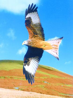
When I approached the easily attained pinnacle, a red kite was soaring aerobatically above the modern plantation.
With its unmistakable whitish to pale red forked tail, the graceful kite is easily distinguished from the heavier and more ponderous buzzard.
Because for once I had set out without an iPOD playing Julio’s greatest hits, I was alerted to his presence by the long, drawn-out wailing, squealing “weieie-ee-ow”; an altogether higher-pitched call than the feline mew of the buzzard.
From the 415 metre Roundabout there is a fine 360 degree view and the wall around the fir trees was provided by the National Trust and Painscastle Community for the millennium. The circular seat within a circle is a dry-stone wall built in June 2000 and offers a suitable perch for watching birds rather than the wartime activity of spotting aeroplanes.
Granted good visibility, you can scan the whole of the Brecon Beacons National Park to the west and the Radnor Hills to the north.
You can also see below you the lake towards which you’re heading on the other side of the lane which you crossed at the bottom.
Whilst undertaking his pastoral duties, Francis Kilvert was no stranger to this moorland and the larks ascending from the lush grass and bracken. Similarly undistracted by an iPOD, because he was walking in the unenlightened 1860s, he was a keen observer of the birdlife.
The rich bubbling trill of the curlew was a particular favourite, and the bulrushes at the shallow end of our lake are an ideal spring nestingplace for this familiar songster.
Five miles to the north-west as the crow flies from the end of our peregrination is Llanbedr Hill. Covering about 20 miles in a typical pilgrimage from Clyro via Llowes to a valley just below the hill, Kilvert would have passed the present walk meeting-place on his way to visit the eccentric, though revered clergyman known as the “Solitary of Llanbedr”.
Describing the little grey hut built without mortar from rough dry stone where he found him, Kilvert wrote “the squalor, the dirt, the dust, the foulness, and wretchedness of the place were indescribable, almost inconceivable.
And in this cabin lives the Solitary of Llanbedr, the Reverend John Price, Master of Arts of Cambridge University and vicar of Llanbedr Painscastle”.
Price also nearly died there three years later when he fell in the fire. With his stomach, bowels and thighs dreadfully burnt, the poor man was forced to stay away from church for three Sundays.
Without such a valid excuse, may I recommend that you embark on this countryside communion. Without your iPOD.
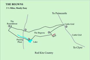
The Begwns
Moorland, red kites, lake, views.
Easier than moderate 3.75 mile walk.
Map: OS Explorer OL13 North Sheet.
Compass might be handy.
1. The Begwns – cattle grid. Start from the space before the second cattle grid three miles above Clyro on the road to Painscastle – by the mast. Put your back to the car park space, with the grid on your R, cross the road and follow moorland path just L of perimeter fence. Bear R at fence corner up slope, due west through bracken, with cars directly behind you. Where the ground levels out, the clump of trees of The Roundabout, your destination, may be visible at “1 o’clock” on the skyline. Fork slightly R, then favour L edge of a crest, with lake at (4) coming into view below L, then gently descend to road.
2. The road is simply confirmation that you’ve come the right way! Now head up the hill on much the same line to the clump of trees on the top. Red kite country.
3. The Roundabout. Find the circle within a circle via the stile in the wall. You’ve reached a mountain top with no real climb.
From The Roundabout cross same stile and take line 150 metres, SSW, straight past trig point. TL, then bear slightly R downwards, towards Lord Hereford’s Knob, if visible, R of bracken, towards lake, also if visible, SE. Go through marshy bracken area to regain road by a passing place in the road. Cross road, SE, following bracken- lined stream on your L and cross it via the PVC duct 100 metres in front of the lake.
4. The lake. TL (NE) past oak tree on near side of lake to go up slope towards fence.
Pick up fence and bend R along track beyond the corner through the gorse. Stay 30 metres up to the L of the hedge which becomes a fence. At a point level with the start of a stone wall by a gate, TL up to a slight crest in the moorland to a point 200 metres above the wall, where the ground levels out. (Llanbedr Hill is on the skyline ahead of you).
5. Right turn. TR to head east with an old ruin back down to your R. Cross a small trickle of a stream, ignore left fork, and bear slightly L at a small cairn. Rise gently up to a crest above the starting point, with a view back to The Roundabout, and descend to the cattle grid/car parking space


Comments: Our rules
We want our comments to be a lively and valuable part of our community - a place where readers can debate and engage with the most important local issues. The ability to comment on our stories is a privilege, not a right, however, and that privilege may be withdrawn if it is abused or misused.
Please report any comments that break our rules.
Read the rules here